

 Seraphina Hughes
 BRISBANE – Tropical Cyclone Alfred, a Category 2 storm churning in the Coral Sea, has slowed its westward march toward south-east Queensland, with the Bureau of Meteorology (BoM) now forecasting a coastal crossing late Friday or early Saturday, March 7-8, 2025. Packing sustained winds of 95 km/h and gusts up to 130 km/h as of 4:00 PM NZDT, Alfred looms 465 km east of Brisbane, threatening heavy rain, destructive winds, and coastal havoc across a 1,000-km stretch from Bundaberg to Grafton, NSW. For NZ Bharat readers, it’s a high-tech tracking tale—satellites, models, and apps collide with a rare cyclone poised to test Australia’s south-eastern resilience.
Latest Snapshot: Position and Power
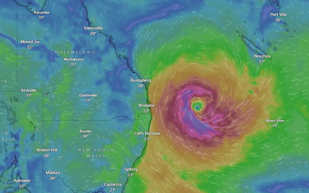
At 1:00 PM AEST (4:00 PM NZDT), BoM pegged Alfred at 26.5°S, 158.2°E—465 km east of Brisbane and 430 km east of the Gold Coast—tracking west at 11 km/h, down from 16 km/h yesterday, per Zoom Earth’s live tracker. With a central pressure of 986 hPa and maximum wave heights of 8.2 meters (27 feet), it’s a “high-end” Category 2, teetering on Category 3 (118-159 km/h winds), per BoM’s 2:56 PM NZDT update. The slowdown—blamed on shifting “steering flow” from a Tasman Sea high—delays landfall, raising fears of prolonged impacts, says BoM’s Dean Narramore in The Guardian (11:25 AM NZDT).
Over 2,421 felt reports from this morning’s North Canterbury 5.1 quake (GeoNet) pale beside Alfred’s reach—20,000 homes in Brisbane alone face flood risk (Brisbane City Council flood map, March 5). Schools, airports, and transport shut across Queensland and NSW, with 230+ public schools, 29 Catholic schools, and 16 TAFE campuses closed in NSW today (ABC News, 8:37 AM NZDT).
Projected Path: A Brisbane Bullseye?
BoM’s latest track map (1:56 PM AEST) plots Alfred crossing between Maroochydore and Coolangatta—Brisbane’s northern suburbs in the crosshairs—late Friday or early Saturday, a shift from Thursday’s forecast due to model “greater variation,” per The Guardian. A “worst-case” stall near Moreton Bay could push it to Saturday, intensifying rain and wind, warns Higgins Storm Chasing’s Thomas Hinterdorfer (The Courier-Mail, March 5). The warning zone spans Double Island Point to Grafton, including Brisbane, Gold Coast, and Byron Bay, with a watch zone from Sandy Cape to Double Island Point, per BoM’s 5:00 AM AEST advisory.
Rainfall totals of 200-400 mm daily—potentially 800 mm multi-day—are forecast south of the eye, with flash flooding risks peaking at high tide Friday night (ABC News, 11:45 AM NZDT). Winds gusting 125-164 km/h could topple trees and damage roofs, while 10-12-meter swells already erode beaches from K’gari to Forster, NSW (Weatherzone, March 3).
Tech and Science: Tracking the Beast
Alfred’s a tech marvel to monitor. BoM’s team, led by Narramore, churns out maps every three hours, blending 100-150 model runs—European, U.S., Japanese, and Australia’s ACCESS—from a “spaghetti” mess to a tighter track, per The Guardian (11:25 AM NZDT). Satellites like Himawari-8 catch its convective churn (ABC News, 2:07 PM NZDT), showing improved patterns hinting at intensification (Sausius_wx on X, 11:26 AM NZDT). Warm Coral Sea waters—1-2°C above average—fuel its rain engine, says Dr. Liz Ritchie-Tyo of Monash University (ABC News, 2:07 PM NZDT), a climate twist NZ’s Alpine Fault quakes can’t match.
Historically rare, Alfred’s a “triplet” born with Cyclones Rae and Seru in February (CSU/CIRU imagery), the first south-east Queensland landfall since 1974’s Zoe (Coolangatta) and Wanda (Brisbane floods, 16 dead), per The Independent (12:00 PM NZDT). Only four cyclones hit this coast from 1971-1974—none since—making Alfred a one-in-35-year event (news.com.au, 4:10 PM NZDT).
Updates: March 6 Fallout
As of 4:00 PM NZDT, prep ramps up. Brisbane’s Lord Mayor Adrian Schrinner warned of a later hit (X, 9:41 AM NZDT), with trains, buses, and ferries halted (The Guardian, 8:28 AM NZDT). Gold Coast Airport shuts at 4:00 PM AEST, per The Independent. PM Anthony Albanese, in Queensland today, deployed 250,000 sandbags via the ADF (SBS News, 5:53 AM NZDT), while NSW’s Essential Energy braces for rural blackouts (The Independent). Social media hums—“waves already huge,” a Gold Coast user posted; “schools out, now what?” a Brisbane parent mused—mirroring ABC News’ live blog urgency.
Queensland Premier David Crisafulli calls it “extremely rare” (The Independent), with 700 mm possible near landfall—three threats: storm surge, winds, and floods (The Guardian, 3:50 PM NZDT). Unity Water’s “don’t flush alternatives” plea (ABC News, 8:37 AM NZDT) underscores stretched systems.
Why It Matters
For NZ’s $20 billion export economy (Stats NZ 2024), Alfred’s fallout could snarl $1.8 billion in India trade (Stats NZ)—ports like Brisbane handle dairy and tech. For Bharat readers, it’s a cyclone kin to India’s Bay of Bengal beasts—62 visa-free spots (NZB News) lag NZ’s 190, but shared hazards bind us. Tech’s the star—BoM’s models and GeoNet’s quake net (5.1 today) show science racing nature. Alfred’s slow crawl tests Australia’s south-east, a wake-up call for NZ’s own shaky ground.
Excerpt
“Alfred’s Category 2 punch looms larger, slower—465 km off Brisbane, it’s a tech-tracked menace promising rain, wind, and erosion. History says it’s rare; today says it’s real. NZ Bharat watches a southern cyclone rewrite the rules.”