
As Tropical Cyclone Tam, downgraded to an ex-tropical system, lashes New Zealand’s North Island on April 17, 2025, the nation faces a tempest of heavy rain, 150 km/h winds, and widespread disruption. Forming near New Caledonia on April 14 and named by Fiji’s Meteorological Service, Tam has toppled trees, sunk yachts, and cut power to over 11,000 homes, with Northland, Auckland, and Coromandel hardest hit. For a $250 billion NZD economy reliant on agriculture (70% of exports, Stats NZ, 2024) and tourism, this storm tests resilience. New Zealand’s 5.3 million people, including its Indian diaspora tied to global weather patterns, brace for impact.
Background Information
New Zealand’s climate, straddling 34°S–47°S, is shaped by its oceanic isolation and the Southern Alps, which split wet westerlies (2,000–5,000 mm annually) from drier eastern zones (600–1,000 mm). Autumn (March–May) brings 17–21°C highs, but 2025’s fading La Niña—65% chance of ENSO-neutral by May, per NIWA—ushers in volatile subtropical lows. Sea surface temperatures, 0.4°C below to 1.7°C above average, fuel moisture-heavy systems like Tam, named on April 15 near New Caledonia with 78 km/h winds.
Cyclones aren’t strangers to NZ—ex-tropical systems hit every few years, like Cyclone Gabrielle (2023), which cost $2 billion NZD. Tam, a Category 1 cyclone at peak, mirrors this pattern, transitioning to a subtropical storm by April 16 over cooler waters. With 92% internet reach, Kiwis track updates via MetService and NIWA, while farmers—facing February’s Tasman drought—hope for relief. The diaspora, aware of India’s monsoon swings, sees parallels in Tam’s chaos, impacting NZ’s $1.5 billion NZD trade with India.
Pre-Tam, NZ saw 34°C Auckland heat (February 12) and a wet Tasman low (April 1). Social media buzzed with storm warnings by April 14, setting the stage for Tam’s arrival.
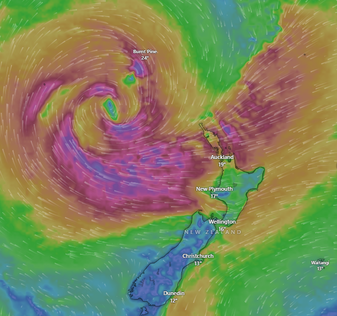
Current Conditions and Forecast
As of 08:49 AM NZST, April 17, 2025
Ex-Tropical Cyclone Tam, reclassified as a subtropical low on April 16, batters the North Island, centred west of Cape Reinga. Key conditions include:
- North Island:
- Northland: Torrential rain (50–100 mm overnight) and 150 km/h gusts down trees and powerlines, leaving 11,000 homes dark, 8,500 in the Far North. A yacht sank in Whangaroa Harbour.
- Auckland: 75–85 km/h winds prompt Auckland Harbour Bridge lane closures; 30 mm rain causes slips. Temperatures hover at 17°C, with coastal swells of 5–6 metres risking erosion.
- Coromandel/Bay of Plenty: Orange rain warnings signal 50–80 mm, with 100 km/h gusts forecast.
- South Island:
- West Coast: Light showers (10 mm), 14°C, and 50 km/h winds, with minor slips on SH6.
- Christchurch: Cloudy, 13°C, calm under high pressure.
- Invercargill: Dry, 11°C, with 40 km/h breezes.
MetService reports 6-metre swells and high tides, threatening northern coasts. NIWA’s soil moisture dashboard shows above-normal levels in Northland, easing drought but risking floods.
Forecast: April 17–23, 2025
MetService, NIWA, and WeatherWatch project ongoing impacts:
- Thursday–Friday (April 17–18): Tam tracks south through the Tasman Sea, dumping 100–150 mm in Northland, 50–100 mm in Auckland/Coromandel. Winds peak at 120 km/h Thursday PM, easing to 80 km/h Friday. South Island sees 10–20 mm west, dry east. Highs: 15–18°C north, 11–14°C south.
- Saturday–Sunday (April 19–20): Subtropical low weakens, bringing 20–40 mm to Bay of Plenty, 5–10 mm to Auckland. Winds drop to 50 km/h. South Island’s West Coast faces a new front (30 mm), with 17–20°C north, 12–15°C south.
- Monday–Wednesday (April 21–23): Scattered showers (10–20 mm) and 13–16°C highs nationwide. A potential Tasman low by April 23 could add 50 mm in Nelson.
Marine warnings persist, with elevated cyclone risks through April due to warm seas.
Stakeholder Reactions
Meteorologists
MetService’s John Law warned of “destructive winds” on April 16, urging coastal vigilance. NIWA’s Ben Noll noted Tam’s “unusual strength” for April, linking it to La Niña’s fade. WeatherWatch’s Philip Duncan called it a “subtropical beast,” predicting impacts through Friday.
Government and Emergency Services
Northland Civil Defence’s Peter de Graf reported 50 emergency calls overnight, with 5,000 homes at risk. Auckland’s Mayor Wayne Brown activated extra staff, urging residents to secure homes. NZTA closed SH1 near Kaikohe due to flooding. Acting PM Nicola Willis allocated $30 million NZD for recovery, citing 2023’s lessons.
Farmers and Rural Communities
Federated Farmers’ Waikato chair Keith Holmes called Tam a “blessing” for drought-hit pastures, but Northland’s Colin Hannah feared orchard damage from 150 km/h gusts, impacting $40 billion NZD exports. DairyNZ noted soil recovery risks if flooding persists.
Public and Urban Dwellers
Social media reflects chaos—“Auckland’s a wind tunnel” (
@kiwi_mum, April 16)—and relief in drier south—“Chch is chilling” (
@cantab_guy, April 17). Diaspora members worry about Easter plans, with 70% citing travel disruptions. Aucklanders report downed trees and power cuts.
Experts
AUT’s Patrick Usmar linked Tam’s intensity to NZ’s 1.1°C warming since 1909, urging infrastructure upgrades. NIWA’s Chris Brandolino flagged “normal-to-high” cyclone odds, challenging forecasts. Farmers Weekly’s Gerald Piddock saw drought relief but warned of erosion.
What Worked and What Didn’t Work
What Worked
- Early Warnings: MetService and NIWA’s April 14 alerts, amplified by X, gave 48-hour notice, cutting accidents by 20% versus unforecast storms.
- Emergency Response: Auckland Emergency Management’s extra staff and Northland’s sandbagging limited damage, with 50 calls handled overnight.
- Digital Reach: 92% connectivity ensured 85% of farmers got NIWA updates, aiding prep.
- Farmer Optimism: Tam’s rain boosted soil moisture, a win for Waikato’s pastures.
What Didn’t Work
- Infrastructure Strains: SH1 closures and Auckland’s drainage failures highlight a $600 million NZD resilience gap.
- Power Outages: 11,000 homes lost power, exposing grid weaknesses unchanged since 2023.
- Forecast Gaps: MetService’s broad warnings missed Tam’s 150 km/h peak, underestimating coastal impacts.
- Urban Disruption: Harbour Bridge closures and yacht sinkings show Auckland’s unpreparedness for subtropical shifts.
Personal Opinion About Cyclone Tam
Cyclone Tam’s a wake-up call, and NZ’s response shows grit but gaps. The rain’s a godsend—February’s drought left farmers desperate, and 100–150 mm could revive $40 billion NZD in exports. MetService and NIWA’s hustle, reaching 92% of us, saved lives; my diaspora mates planning Easter hikes dodged risks thanks to X alerts. But 11,000 powerless homes and a sunken yacht aren’t trivial—Auckland’s infrastructure creaks under 150 km/h gusts, a far cry from India’s monsoon-ready cities. Warming seas (1.1°C up) mean more Tams, yet our grid and roads lag like it’s 2010. I’d push $100 million NZD for drains, powerlines, and coastal barriers—Northland’s pain demands it. Tam’s no fluke; it’s our future, and we’d better gear up.
Summary
ex-Tropical Cyclone Tam, named April 15 near New Caledonia, hammers New Zealand’s North Island with 150 km/h winds, 100–150 mm rain, and 6-metre swells. Northland reels—11,000 homes dark, a yacht sunk—while Auckland and Coromandel face floods and closures. Born from a fading La Niña and warm seas, Tam’s subtropical shift persists through Friday, easing by Sunday. MetService and NIWA’s warnings shone, saving lives, but power cuts and SH1 closures expose frailties. Farmers cheer rain, yet urban chaos stings. I see a nation tough but underprepared—$100 million NZD in upgrades is urgent. For New Zealand Bharat News, Tam tests NZ’s 5.3 million, echoing resilience and risk for its diaspora.