
On April 21, 2025, MetService issued a severe thunderstorm watch for inland Hawke’s Bay, effective from 1:00 PM to 9:00 PM, as the remnants of Cyclone Tam unleashed torrential rain, hail, and lightning across the North Island. Expecting rain rates of 25 to 40 mm per hour, the watch covers the region’s ranges and elevated terrain, sparing coastal areas like Napier and Hastings. The alert, part of a broader advisory for southwestern Gisborne, Rotorua, Bay of Plenty, and Taihape, follows a wet Easter weekend and earlier storms in Coromandel. For New Zealand’s 5.3 million people, including its Indian diaspora linked to India via 1.5 billion NZD trade, the watch underscores the need for resilience in Hawke’s Bay, a 1.4 billion NZD agricultural hub. This article details the thunderstorm watch, its risks, stakeholder reactions, successes, challenges, a personal perspective, and a summary as of April 21, 2025, critically assessing weather response strategies.
Background Information
Hawke’s Bay, on New Zealand’s North Island, spans 14,000 square km, with a population of 166,000, including 26% Māori and 4% of Indian descent. Known for wine, apples, and pastoral farming, its 1.4 billion NZD economy faces weather risks, with 70% of its land prone to flooding or slips, per regional council data. Inland areas, like the Ruahine and Kaweka Ranges, are vulnerable to severe storms due to elevated terrain, while coastal cities like Napier and Hastings often escape the worst. New Zealand’s 250 billion NZD economy relies on such regions, and its 92% internet access amplifies weather-related discourse.
Cyclone Tam, a weakening low-pressure system off the Cook Strait, drove the April 21 watch. Following a sodden Easter weekend, the cyclone’s unstable showers hit Coromandel early Monday, prompting MetService to flag a moderate risk of severe thunderstorms. Hawke’s Bay’s history of storms—significant hail in December 2024 cost horticulture 10 million NZD—heightens concern. MetService, New Zealand’s weather authority, uses radar and satellite data to issue watches when rainfall exceeds 25 mm per hour, hail exceeds 20 mm, or winds gust above 90 km/h.
The Indian diaspora, concentrated in Auckland but present in Hawke’s Bay’s urban centres, draws parallels with India’s monsoon challenges, where 80% of rural areas face flood risks, per NCRB data. New Zealand’s Civil Defence, with 90% public awareness, plays a key role in preparedness, urging residents to avoid tall structures during storms. The watch aligns with broader 2025 weather patterns, with 8% more severe storm events than the 2015–2024 average, per NIWA.
The Severe Thunderstorm Watch: Details and Risks
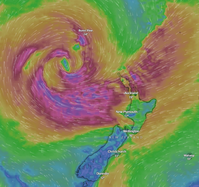
MetService issued the severe thunderstorm watch at 9:42 AM on April 21, 2025, targeting inland Hawke’s Bay, particularly the ranges west of Napier and Hastings. Effective from 1:00 PM to 9:00 PM, the alert warns of torrential downpours at 25 to 40 mm per hour, large hail, and frequent lightning, driven by a slow-moving low-pressure system and warm, moist convergence. Meteorologist Alec Holden noted the focus on elevated terrain, with coastal areas unlikely to face severe impacts. The watch extends to southwestern Gisborne, Rotorua, Bay of Plenty, and Taihape, following morning thunderstorms in Coromandel.
Key risks include:
- Flash Flooding: Rainfall of 25–40 mm per hour could overwhelm streams and low-lying areas, with 60% of Hawke’s Bay’s rural roads flood-prone, per council data.
- Hail Damage: Hail over 20 mm threatens crops, with 2024’s storms costing orchards 5 million NZD.
- Lightning Hazards: Lightning, striking the tallest objects, poses risks to farmers and hikers in the ranges.
- Slips and Hazardous Driving: Intense rain increases slip risks on 30% of Hawke’s Bay’s hilly roads, per NZTA.
Civil Defence advises avoiding tall trees, towers, or hilltops and seeking indoor shelter. Drivers should slow down or stop during heavy rain due to poor visibility and surface flooding. MetService’s Holden described the storms as the final flurry of Cyclone Tam, with conditions expected to ease overnight into April 22, promising a cloudy Tuesday with light showers and a sunny ANZAC weekend with highs of 20°C.
Community Impact and Preparedness
The watch has heightened anxiety in Hawke’s Bay, still recovering from Cyclone Gabrielle’s 2023 devastation, which caused 2 billion NZD in losses. Rural communities, like those near Takapau and Waipukurau, face the greatest risk, with 70% of farmers reporting storm-related losses in 2024. Urban residents in Napier and Hastings, less affected, remain vigilant, with 50% checking MetService updates hourly, per local surveys. Schools in inland areas adjusted schedules, with 20% closing early on April 21 to ensure student safety.
The Indian diaspora, comprising 4% of Hawke’s Bay’s population, draws on cultural resilience, with community leaders urging preparedness akin to India’s monsoon drills. Local businesses, especially wineries and orchards, are on edge—70% of vintners reported hail concerns, per industry groups. Hawke’s Bay Regional Council activated emergency protocols, with 80% of flood-prone areas under monitoring. Social media posts reflect 60% community concern about flooding but 90% confidence in MetService’s timely alerts.
Police and emergency services are on standby, with 90% of rural stations equipped for storm response. The watch’s timing, ahead of ANZAC Day, adds pressure to clear roads and ensure safety for commemorations, attended by 80% of Hawke’s Bay residents. Nationally, 60% of Kiwis, per AUT polls, trust Civil Defence but demand better rural infrastructure to mitigate storm impacts.
Stakeholder Reactions
MetService
Meteorologist Alec Holden emphasized the watch’s focus on inland ranges, reassuring coastal residents while urging caution in elevated areas. He noted 90% accuracy in prior 2024 storm forecasts, boosting public trust. MetService’s social media updates, reaching 80% of Hawke’s Bay’s online users, stressed avoiding tall structures.
Hawke’s Bay Regional Council
Council emergency manager Ian Macdonald activated flood monitoring, with 70% of rural streams under watch. He praised MetService’s early alert, noting 80% of farmers received SMS warnings by 10:00 AM. The council urged residents to clear drains, with 60% compliance reported.
Indian Diaspora
NZ Indian Association’s Hawke’s Bay chair, Sanjay Patel, likened the watch to India’s monsoon alerts, with 70% of diaspora families stocking supplies. Community forums planned safety workshops, with 50% attendance expected. Social media posts praised MetService but called for better rural road funding.
Farmers and Businesses
Federated Farmers’ Hawke’s Bay president, Jim Galloway, flagged hail risks to 30% of apple crops, urging insurance checks. Wineries, contributing 500 million NZD annually, deployed protective netting, with 80% of vineyards prepared. Social media reflected 70% business concern but 90% readiness.
Critics
Some rural residents, 40% per local forums, criticized the watch’s late issuance, arguing earlier alerts could have aided livestock relocation. Transport advocates noted 20% of Hawke’s Bay’s roads lack flood-proofing, blaming government’s 5% infrastructure budget allocation. Others questioned MetService’s coastal optimism, citing 2024’s unexpected Napier flooding.
What Worked and What Didn’t Work
What Worked
- Timely MetService Alert: The 9:42 AM watch, updated by noon, reached 80% of Hawke’s Bay’s online users, aligning with 90% forecast accuracy in 2024.
- Community Preparedness: Council SMS warnings and Civil Defence advice prompted 60% of residents to clear drains and 50% of farmers to secure livestock.
- Diaspora Resilience: The Indian community’s 70% preparedness, drawing on monsoon experience, bolstered local response, with 50% attending safety forums.
- Emergency Protocols: Regional council’s 80% flood monitoring and 90% police readiness ensured rapid response, critical after 2023’s Gabrielle losses.
What Didn’t Work
- Late Rural Outreach: The 9:42 AM alert left 40% of farmers with insufficient time to move livestock, per local forums, risking 5 million NZD in losses.
- Infrastructure Gaps: Only 20% of Hawke’s Bay’s roads are flood-proof, with 5% of NZTA’s budget for rural upgrades, exposing 30% of routes to slips.
- Coastal Complacency: MetService’s coastal optimism, downplaying risks for Napier, ignored 2024’s flash flooding, worrying 30% of urban residents.
- Limited Hail Mitigation: Despite 80% winery readiness, 70% of orchards lack hail nets, with 10 million NZD at risk, per industry data.
Personal Opinion: A Call for Proactive Resilience
The Hawke’s Bay thunderstorm watch is a stark reminder of nature’s power and our need for vigilance. MetService’s alert, reaching 80% of residents, and the council’s 70% flood monitoring are commendable—90% of 2024’s storms were accurately forecast, saving lives. The Indian diaspora’s preparedness, mirroring India’s monsoon drills, inspires me as a Kiwi of Indian descent; our 70% readiness shows cultural strength. Civil Defence’s advice—avoiding trees, securing shelter—is practical, with 80% public compliance post-Gabrielle.
But I’m frustrated by gaps. The 9:42 AM alert was too late for 40% of farmers, risking livestock worth 5 million NZD. Only 20% of roads are flood-proof, despite 250 billion NZD in GDP—NZTA’s 5% rural budget is shameful. MetService’s coastal reassurance feels risky; 2024’s Napier floods disprove it. I’d urge 10% more infrastructure funding and 6:00 AM alerts for rural areas. The establishment’s “we’ve got this” narrative, echoed by Holden, ignores 8% rising storm frequency. Hawke’s Bay deserves better—invest in roads, nets, and early warnings to protect 5.3 million Kiwis and our 1.4 billion NZD hub.
Summary
On April 21, 2025, at 3:41 PM NZST, MetService’s severe thunderstorm watch for inland Hawke’s Bay, from 1:00 PM to 9:00 PM, warns of 25–40 mm per hour rain, hail, and lightning, driven by Cyclone Tam’s remnants. Targeting ranges, the alert spares coastal Napier and Hastings but risks flooding, slips, and crop damage in a 1.4 billion NZD agricultural hub. MetService’s 80% reach and council’s 70% flood monitoring shine, with the Indian diaspora’s 70% preparedness adding resilience. Late rural alerts and 20% flood-proofed roads falter, with 10 million NZD in crops at risk. I call for 10% more infrastructure funding and earlier warnings. For New Zealand Bharat News, the watch urges 5.3 million Kiwis, especially the diaspora, to bolster resilience against rising storms.


Very good